
macid
macid
Recently Published

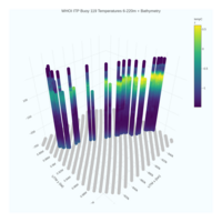
WHOI ITP Buoy 119 Temperatures 6-220m + Bathymetry
WHOI ITP 119 / NOAA Bathy Data
R code:
https://github.com/macidR/arcticPlotting
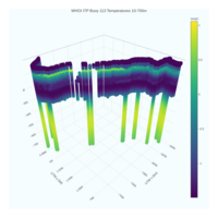
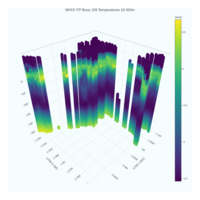
WHOI ITP Buoy 113 Temperatures 10-700m
Depth temperature profiles. Coordinates converted to UTM for fair cartesian projection, hover over data point to see date & lat/lon info.
"The Ice-Tethered Profiler data were collected and made available by the Ice-Tethered Profiler Program (Toole et al., 2011; Krishfield et al., 2008) based at the Woods Hole Oceanographic Institution (https://www.whoi.edu/itp)."
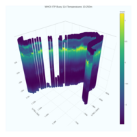
WHOI ITP Buoy 114 Temperatures 10-250m
Depth temperature profiles. Coordinates converted to UTM for fair cartesian projection, hover over data point to see date & lat/lon info.
"The Ice-Tethered Profiler data were collected and made available by the Ice-Tethered Profiler Program (Toole et al., 2011; Krishfield et al., 2008) based at the Woods Hole Oceanographic Institution (https://www.whoi.edu/itp)."
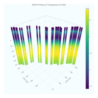
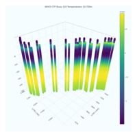
WHOI ITP Buoy 117 Temperatures 10-700m
Depth temperature profiles. Coordinates converted to UTM for fair cartesian projection, hover over data point to see date & lat/lon info.
"The Ice-Tethered Profiler data were collected and made available by the Ice-Tethered Profiler Program (Toole et al., 2011; Krishfield et al., 2008) based at the Woods Hole Oceanographic Institution (https://www.whoi.edu/itp)."
WHOI ITP Buoy 118 Temperatures 10-700m
Depth temperature profiles. Coordinates converted to UTM for fair cartesian projection, hover over data point to see date & lat/lon info.
"The Ice-Tethered Profiler data were collected and made available by the Ice-Tethered Profiler Program (Toole et al., 2011; Krishfield et al., 2008) based at the Woods Hole Oceanographic Institution (https://www.whoi.edu/itp)."
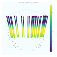
WHOI ITP Buoy 119 Temperatures 10-700m
Depth temperature profiles. Coordinates converted to UTM for fair cartesian projection, hover over data point to see date & lat/lon info.
"The Ice-Tethered Profiler data were collected and made available by the Ice-Tethered Profiler Program (Toole et al., 2011; Krishfield et al., 2008) based at the Woods Hole Oceanographic Institution (https://www.whoi.edu/itp)."

WHOI ITP Buoy 116 Temperatures 10-700m
Depth temperature profiles. Coordinates converted to UTM for fair cartesian projection, hover over data point to see date & lat/lon info.
"The Ice-Tethered Profiler data were collected and made available by the Ice-Tethered Profiler Program (Toole et al., 2011; Krishfield et al., 2008) based at the Woods Hole Oceanographic Institution (https://www.whoi.edu/itp)."

WHOI ITP Buoy 107 Temperatures 10-350m
10-350m depth temperature profiles from buoy 107. converted to UTM for fair cartesian projection, hover data point over to see date & lat/lon info . "The Ice-Tethered Profiler data were collected and made available by the Ice-Tethered Profiler Program (Toole et al., 2011; Krishfield et al., 2008) based at the Woods Hole Oceanographic Institution (https://www.whoi.edu/itp)."
WHOI ITP Buoy 109 Temperatures 10-350m
10-350m depth temperature profiles from buoy 109. converted to UTM for fair cartesian projection, hover data point over to see date & lat/lon info . "The Ice-Tethered Profiler data were collected and made available by the Ice-Tethered Profiler Program (Toole et al., 2011; Krishfield et al., 2008) based at the Woods Hole Oceanographic Institution (https://www.whoi.edu/itp)."

WHOI ITP Buoy 108 Temperatures 0-700m; skip = 4
10-700m depth, skip 4, temperature profiles from buoy 108. converted to UTM for fair cartesian projection, hover data point over to see date & lat/lon info . "The Ice-Tethered Profiler data were collected and made available by the Ice-Tethered Profiler Program (Toole et al., 2011; Krishfield et al., 2008) based at the Woods Hole Oceanographic Institution (https://www.whoi.edu/itp)."

WHOI ITP Buoy 108 Temperatures
10-300m depth temperature profiles from buoy 108.
converted to UTM for fair cartesian projection, hover data point over to see date & lat/lon info .
"The Ice-Tethered Profiler data were collected and made available by the Ice-Tethered Profiler Program (Toole et al., 2011; Krishfield et al., 2008) based at the Woods Hole Oceanographic Institution (https://www.whoi.edu/itp)."
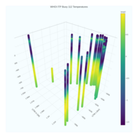
WHOI ITP Buoy 112 Temperatures
10-700m depth temperature profiles from buoy 112. converted to UTM for fair cartesian projection, hover data point over to see date & lat/lon info . "The Ice-Tethered Profiler data were collected and made available by the Ice-Tethered Profiler Program (Toole et al., 2011; Krishfield et al., 2008) based at the Woods Hole Oceanographic Institution (https://www.whoi.edu/itp)."