
NeKuz
Nicolas Kuzminsi
Recently Published
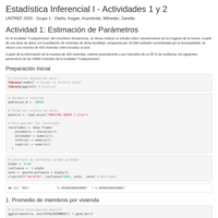
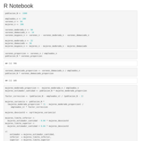
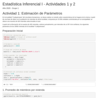
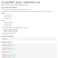
ACTIVIDAD DE CLASE ESTIMACIÓN DE PARÁMETROS
Trabajo Práctico para Estadistica Inferencial I, UNTREF (2020).
Country Flags Explorer Pitch Presentation
This application shows a choropleth map of the world countries coloured according to the colors of their flags. It was made as an R Language little project for the “Developing Data Products Course by Johns Hopkins” on Coursera, using Shiny web framework and Leaflet map visualization. The base world map is provided online by OpenStreetMap, the political land borders (polygons) are from Geo-Maps. I've published this project's source code on Github, which I've made freely available for anyone to use and modify for their own project.
Buenos Aires Public Officers Salaries
Plotly Excercise
Type of weather events with greatest impact on USA
Which type of events had the greatest impact on the last years recorded on USA, upon their outcome on human population health, considering casualties of fatalities and injured, as well as their economic impact.
(for the Reproducible Research Course Project 2 on Coursera)