
aagarwal29
Ankit
Recently Published
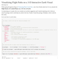
R : 3-D Interactive Globe Visualization to Plot Flight Routes along with some GeoSpatial Data Processing
3-D visualization of Flight Route Data on an Interactive 3-D Globe using threejs package. Also added basic geospatial data processing techniques like Reverse Geocoding, distance and bearing calculation etc.
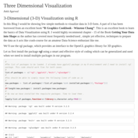
R : Interactive 3-D (Three Dimensional) Visualization of Data and Plot Predicted Values on the 3-D graph
In this article we will get into the details of plotting a 3-D graph using rgl package.