
cxiao
Chuliang Xiao
Recently Published
Hydrograph with ggplot2 and plot
Hydrograph: streamflow + precipitation on top, aligning axes
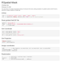
geospatial masking
The script shows a R example of geospatial masking in the Maumee River basin, plotting precipitation of a gridded Lambert netCDF file with a watershed in polygon shapefile on Google Map.
mapview with hydrogrphy popups
Hydrographs from National Water Model in the Great Lakes