
djn34
Dylan Nagy
Recently Published
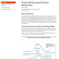
[Tutorial] Geospatial Data Resources
This guide goes over several commonly used geospatial data sources and provides several tips to assist with common uses of the data. Sources include Census Bureau data, US Department of Housing and Urban Development crosswalk files, and the Area Deprivation Index.
[Tutorial] Enhanced Two-Step Floating Catchment Area (E2SFCA)
This tutorial goes over the enhanced two-step floating catchment area, a method for creating an index that measures spatial accessibility for healthcare providers that factors in the demand on that provider's services and how much of that service the provider can supply.
[Tutorial] Common Practices for Map Design
This tutorial goes over several commonly used practices while designing static and interactive maps.
[Tutorial] Building Isochrones with HERE
This tutorial describes what isochrones are and illustrates a couple of basic reasons to use them. The examples use HERE's isoline API to generate isochrones around three hospitals in the same region.
[Tutorial] Drive Time and Distance with Bing Maps
This tutorial demonstrates how to use the Bing Maps API to calculate drive time (in minutes) and driving distance (in miles) between two locations.
[Tutorial] Geocoding with Bing Maps
This tutorial demonstrates how to geocode physical locations using the Bing Maps API. This technique converts a street address into geospatial coordinates, which is useful for calculating drive time and distance between multiple locations, using a location in geospatial analyses, plotting locations on a map, and more.
[Exercise] HERE Isolines Investigation
This exercise investigates isolines (equivalent to isochrones) created by the HERE Isoline API. HERE’s API for creating catchment areas allows for specifying if the areas should be drawn by distance (in meters), time, or by consumption in watt hours, and also allows a user to indicate the date and time at the starting location when creating an isochrone to simulate real-world traffic. The accuracy of these isolines and the efficiency of creating them are compared to isochrones made with Mapbox and Open Source Routing Machine (OSRM) and with drive time calculations to points of interest using the Bing Maps Routing API.
[Exercise] OSRM Isochrone Resolution Comparison
This exercise compares isochrones created by Open Source Routing Machine (OSRM) with different specified resolutions. The isochrones were built from the starting coordinates of City Hall in Philadelphia, PA, and include catchment areas for a 0 to 5 minute drive, a 5 to 10 minute drive, and a 10 to 15 minute drive from City Hall. The effectiveness of the isochrones created by each service were analyzed with calculated drive times to 10 points of interest that were either within the city of Philadelphia or the neighboring city, Camden, NJ. Drive times between City Hall and each point of interest were calculated with the Bing Maps Routing API during a time that should have light to moderate traffic.
[Exercise] Mapbox and OSRM Isochrone Comparison
This exercise compares isochrones created by Mapbox and Open Source Routing Machine (OSRM). The isochrones were built from the coordinates of City Hall in Philadelphia, PA, and include catchment areas for a 0 to 5 minute drive, a 5 to 10 minute drive, and a 10 to 15 minute drive from City Hall. The effectiveness of the isochrones created by each service were analyzed with calculated drive times to 10 points of interest that were either within the city of Philadelphia or the neighboring city, Camden, NJ. Drive times between City Hall and each point of interest were calculated with the Bing Maps Routing API.