
fecr2o4
Paul Low
Recently Published

BigM
WIP

Coviduro[Again]
WIP...
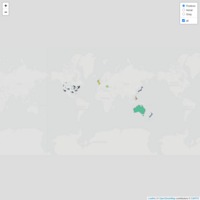
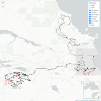
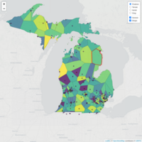
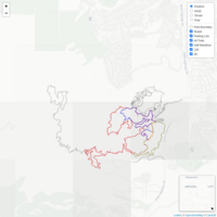
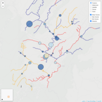
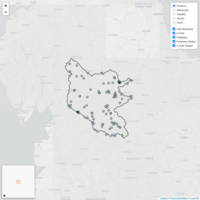
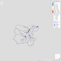
Map of regional cycling subreddits
Map of 50 regional cycling subreddits using Current Metropolitan Statistical Areas (MSAs) for US cities and Census Metropolitan Areas (CMAs) for Canadian cities. Activity data from the past 6 months. Work in progress.
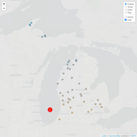
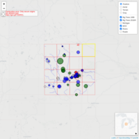
Map of groomed snowbiking trails in Michigan
This a map of all of the places that I know of (or could find with a little googling) in Michigan that groom trails for snow biking (when conditions allow, of course). This list is as inclusive as possible meaning that if I have ever heard or read of a trail being groomed it is on here (even if it was groomed once back in 2016). Click on a circle marker to see the trail name and a link to information about current(?) trail conditions. Please comment (https://www.reddit.com/r/MichiganCycling/) with additions and corrections if you know of additional trails or better links. Thank you.
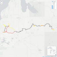
MJ 2021 Map
Interactive map showing differences between the 2021 Marji Gesik 50-and 100-mile courses and course used in 2018 and 2019. For both races (50 and 100 milers), black indicates a section of course that was/will be used for the 2018, 2019, and 2021 editions, green indicates a section that is used in 2021 and was not used in 2018 and/or 2019, and red indicates a section that was used in 2018 and/or 2019 and will not be used in 2021. All map layers are enabled at the start and may be hidden using the toggles in the upper right of the screen. The base map can be changed in the upper right as well. Right click drag to pan, mouse wheel roll to zoom, and right click on a feature to display an information popup. While most of the map functionalities will work using a touch screen, they are optimized for computer setup with a mouse or similar device. Course maps for 2021 are from publicly available .gpx files provided by the race organization and course maps for 2018 and 2019 are from participants. Elevation calculations are made using a 1 arcsecond DEM (about 25 meters). This map was created very quickly in the Lower Peninsula by a person who is only vaguely familiar with the trail systems involved and who not affiliated with the race organization in any official capacity. Please use accordingly.
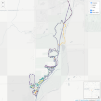
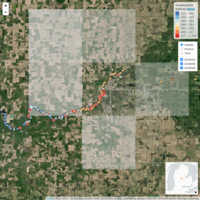
IceMans
Comparison between 2019 and 2021 courses for The Iceman Challenge, a mountain bike race in Michigan's Lower Peninsula. 2019 route is from the .gpx track created by one of the participants; 2021 route is from the race's website: https://ridewithgps.com/routes/36060572
MoMo2MTB
How far away are the trails? This is an interactive map of some "nearby" places to ride trail bikes (relative to my LBS, Motorless Motion). Some are purpose-build MTB trails, others are public, natural-surface trails where mountain bikes are allowed. This is a work in progress and is (obviously) not an exhaustive list.
CamRock Climbs
later

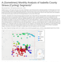
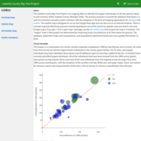
Isabella County Strava Segments
A (sometimes) monthly analysis of Isabella County Strava (cycling) segments. Part of my ongoing series "Overanalyzing Unimportant Things."
Isabella County Big Tree Project
Map of the largest known individual(s) for 63 species in located within Isabella County in the central lower peninsula of Michigan (USA). This map is a continuation of a project originally completed in 1999 by Hud Keenan and 24 of the trees from his list are still the largest known individuals in the county (shown in green). For 31 trees, new largest individuals have been identified (shown in blue) and 20 additional species have been added to the list, 13 of which are shown in purple. For additional context and discussion, see rpubs.com/fecr2o4/btPlots . Last updated November 20, 2020.
Voronoi map of 387 Michigan Breweries
A Voronoi map partitions an area (in this case, Michigan) into sub-regions based on geometric proximity to a given set of points (in this case, active beer breweries). I compiled the list from the Brewers Association membership directories and the Michigan Brewers Guild membership list with a few additions from the Brewsader app (Grand Rapids area) and my friend’s Untapped history. I would like to call it “All of the breweries in Michigan” but I am sure that there are a few that are missing and it does not include 6 breweries that are described as being temporarily closed on Google Maps (on 8/31/2020).
Map of local bike shops, bike coops, and bike repair businesses in and near Michigan (USA)
Last updated August 19, 2020. Interactive map of 200 Local Bike Shops (LBS), bike coops, and bike repair businesses in MI and 9 close to the MI border in IN and OH that might be the closest LBS to someone in MI. Fill color is based on walkscore. Database: https://tinyurl.com/y6n28msn This is a living document. If you have corrections of additions, please let me know.
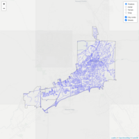
Santa Fe Streets
Every single street in Santa Fe, NM. Data from 2010 US Census.
Isabella County Big Tree Project Plots
See Text...
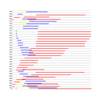
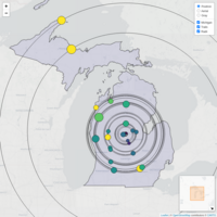
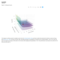
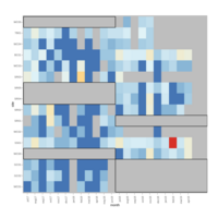
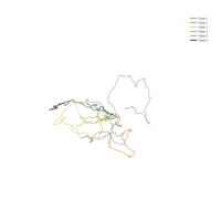
Analysis of Intersections for 3 simultaneous races
x (horizontal) axis = time. Hover over points to see arrival times.
Preliminary Course Maps
Awaiting approval...

Mmap
...to come later
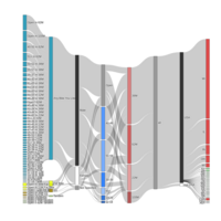
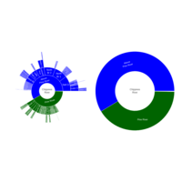
Sankey Diagram of 2019 Barry-Roubaix Categories
Sankey diagram of 3535 participants in 61 different categories for the 2019 Barry-Roubaix Gravel Road Races with super classifications of bike type, sex, age group, race distance, and self-reported rider origin. Publicly available data from https://www.newtontiming.com/results/19/brx/brx-pre-19.html and https://www.bikereg.com/Confirmed/39928
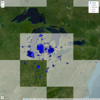
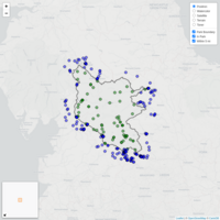
brMap
Map of 3535 participant origins in the 2019 Barry-Roubaix Gravel Road Races. Locations are self reported to the nearest city/town and circle size corresponds to number of participants reporting that location. Data from https://www.bikereg.com/Confirmed/39928
Tree Plot
Updated 4/7/2019, additional description forthcoming

WC bacteria map
Stand alone map from http://rpubs.com/fecr2o4/wcb
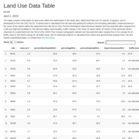
WC Land Use Data Table
Online data table for http://rpubs.com/fecr2o4/WCB
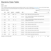
Bacteria Data Table
An online data table for http://rpubs.com/fecr2o4/WCB

Impaired Waters
Map of "2018 Impaired Waters" in the Maury River Watershed and Rockbridge County from information in the 2018 Impaired Waters - 303(d) List (Virginia, USA). Category 4A streams in orange, category 5A in red, delisted streams in green, and some additional (not listed) streams in blue. Click on a stream segment to see information about its listing.
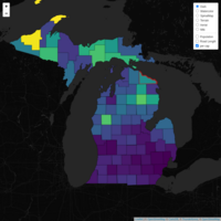
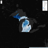
Michigan road length per capita (by county)
Data (US Census and MIDOT road shapefiles) from 2017. Prism (3D) version at https://skfb.ly/6Hrzt
Interactive map of Maury River Volunteer Benthic Invertebrate Monitoring Activities
Results of almost two decades of stream surveys in the Maury River Watershed (and an interactive map of local impaired streams). Last updated 2/13/2019
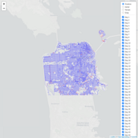
ess Map(s)
Map of completed (as of 12/18/2018) street segments for Rickey Gates' Every Single Street Project.
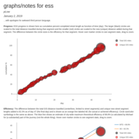
ess Graphs
Some graphs for ess. Part of an ongoing private discussion.
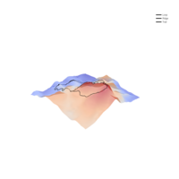
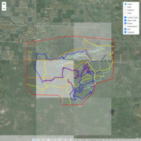
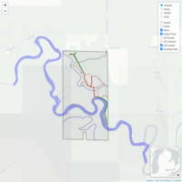
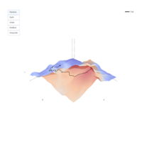
Bundy Surface Map
New trail construction at Bundy Hill Preserve in Central Michigan as of September, 2018. Trail location is smartphone-gps-running-through-a-summer-forest accurate and I am still not happy about how the trail and surface reconcile in 3D. Elevation data from the new(ish- April, 2018) 1/3 arc-second DEM published of this area published by the USGS: https://viewer.nationalmap.gov/basic/?basemap=b1&category=ned,nedsrc&title=3DEP%20 View Heat map version at: http://rpubs.com/fecr2o4/bhmFinal and contour map version of area at: http://rpubs.com/fecr2o4/bcmFinal
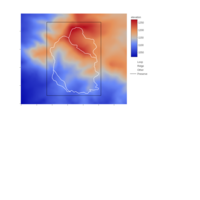
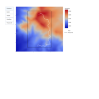
Bundy Contour Map
New trail construction at Bundy Hill Preserve in Central Michigan as of September, 2018. There is now a new trail that connects the parking area on River Road with the summit. Trail distances are in miles and trail location is smartphone-gps-running-through-a-summer-forest accurate. Elevation data from the new(ish- April, 2018) 1/3 arc-second DEM published of this area published by the USGS: https://viewer.nationalmap.gov/basic/?basemap=b1&category=ned,nedsrc&title=3DEP%20 View heat map version at: http://rpubs.com/fecr2o4/bhmFinal and surface map version of area at: http://rpubs.com/fecr2o4/bsmFinal
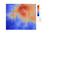
Bundy Heat Map
New trail construction completed at Bundy Hill Preserve in Central Michigan as of September, 2018. Trail distances are in miles and trail location is smartphone-gps-running-through-a-summer-forest accurate. Elevation data from the new(ish- April, 2018) 1/3 arc-second DEM published of this area published by the USGS: https://viewer.nationalmap.gov/basic/?basemap=b1&category=ned,nedsrc&title=3DEP%20 View Heat map version at: http://rpubs.com/fecr2o4/bhmFinal and surface map version of area at: http://rpubs.com/fecr2o4/bsmFinal
2018 Breck Epic Course(s)
3D scatter plot for the 2018 Breck Epic mountain bike stage race in Colorado (USA). Vertical exaggeration is about 4-5X. I am not affiliated with the race and this map is from course information made available to the public on their website: https://breckepic.com/the-course/


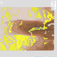
Green River Raft Trip
State-scale interactive bedrock geology map of area surrounding the Split Mountain Anticline. Data from https://mrdata.usgs.gov/geology/state/state.php?state=UT Quaternary alluvial and landslide deposits shown in yellow, clastic sedimentary rocks (mostly sandstones) are shown in brown with older rocks shown with darker tints and the oldest rocks (a carbonate unit) show in gray.
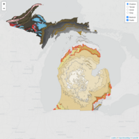
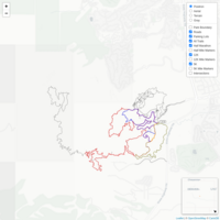
Interactive Bedrock Geology Map of Michigan
Interactive bedrock geology map of Michigan. Data from https://mrdata.usgs.gov/geology/state/state.php?state=MI
Colors are: clastic sedimentary = brown --> darker with age
carbonate sedimentary = gray --> darker with age
igneous = red --> darker with age
metamorphic = blue --> darker with age
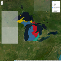
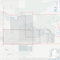
Great Lake- Level Watersheds of Michigan
Interactive watershed map of Michigan showing which areas of the state are upslope from the four bordering Great Lakes. Saint Mary's River water is classified as Huron for this map (following the Huron-Superior separation at the Sault Locks on the USGS topo map). Data parsed from the USGS HUC 12 dataset.

Audubon Woods Preserve Trail Map
Map of the trail system, a short spring-fed sinking stream, and a few pictures and the Audubon Woods Preserve in Isabella County Michigan. http://www.chippewawatershedconservancy.org/audubon-woods-preserve/
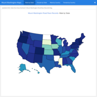
Mount Washington Road Race State and Country Records
Map of state and country records for the Mount Washington Road Race. Data compiled by Dave Dunham https://mtwashingtonrecords.blogspot.com/
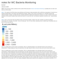
Woods Creek Bacteria Notes
Some Notes to accompany "Woods Creek Bacteria Monitoring" rpubs.com/fecr2o4/WCB
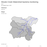
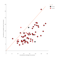
Woods Creek Bacteria Monitoring
Some preliminary results from ongoing volunteer sampling efforts in the Woods Creek Watershed (Lexington, Virginia, USA to assess concentration of <i>E. coli</i>/coliform bacteria. Last updated July 21, 2018 to include all collected samples for July, 2018 and the four new samples sites for the 2018-2019 sample season.
Bundy Surface Map
Progress on new trail construction at Bundy Hill Preserve in Central Michigan as of June 14, 2018. There is now a new trail that connects the parking area on River Road with the summit. Trail location is smartphone-gps-running-through-a-summer-forest accurate and I am still not happy about how the trail and surface reconcile in 3D. Elevation data from the new(ish- April, 2018) 1/3 arc-second DEM published of this area published by the USGS: https://viewer.nationalmap.gov/basic/?basemap=b1&category=ned,nedsrc&title=3DEP%20 View Heat map version at: http://rpubs.com/fecr2o4/bhm and contour map version of area at: http://rpubs.com/fecr2o4/bcm

Bundy Contour Map
Progress on new trail construction at Bundy Hill Preserve in Central Michigan as of June 14, 2018. There is now a new trail that connects the parking area on River Road with the summit. Trail distances are in miles and trail location is smartphone-gps-running-through-a-summer-forest accurate. Elevation data from the new(ish- April, 2018) 1/3 arc-second DEM published of this area published by the USGS: https://viewer.nationalmap.gov/basic/?basemap=b1&category=ned,nedsrc&title=3DEP%20 View heat map version at: http://rpubs.com/fecr2o4/bhm and surface map version of area at: http://rpubs.com/fecr2o4/bsm
Bundy Heat Map
Progress on new trail construction at Bundy Hill Preserve in Central Michigan as of June 14, 2018. There is now a new trail that connects the parking area on River Road with the summit. Trail distances are in miles and trail location is smartphone-gps-running-through-a-summer-forest accurate. Elevation data from the new(ish- April, 2018) 1/3 arc-second DEM published of this area published by the USGS: https://viewer.nationalmap.gov/basic/?basemap=b1&category=ned,nedsrc&title=3DEP%20 View Heat map version at: http://rpubs.com/fecr2o4/bhm and surface map version of area at: http://rpubs.com/fecr2o4/bsm
Yorkshire Dales Pubs- Hilly Version
2 down, 106 to go (updated 13 June, 2018
Pubs in (and around) the Yorkshire Dales National Park
Map of 72 pubs in the Yorkshire Dales National Park (green) and an additional 218 within 5 miles of the park boundary (blue). Pub information from: https://data.world/getthedata/open-pubs (updated Dec, 2016) and park boundary shapefile from: https://data.gov.uk/dataset/671bdd94-f9e8-41fd-997c-c371fca050de/national-parks-august-2016-full-extent-boundaries-in-great-britain (updated Aug, 2016).
Michigan County High Points
data from: https://www.summitpost.org/michigan-county-highpoints/369617
http://www.cohp.org/images/Google/google_earth_main.html
http://www.peakbagger.com/list.aspx?lid=13402

Maury River Volunteer Benthic Invertebrate Monitoring
Results of almost two decades of stream surveys in the Maury River Watershed
(and an interactive map of local impaired streams). Last updated 2/3/2019
Chippewa River Conductivity- Leaflet Version
Map of specific conductance and water temperature measurements from the Chippewa River and its tributaries in and near Mount Pleasant, Michigan (USA) taken during the spring of 2018. This is mostly just a fun kayaking trips for me but I take some measurements along the way (also for fun). There is a MapView version at: http://rpubs.com/fecr2o4/ChipRiverMapView

ChipRiverMapView
MapView version of map http://rpubs.com/fecr2o4/ChipRiverLeaflet
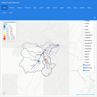
Woods Creek Bacteria Monitoring Map
Preliminary data from an ongoing sampling effort in the Woods Creek Watershed in and around Lexington, Virginia (USA) to assess levels of <i>E. coli</i>/coliform bacteria determined using Coliscan Easygel, incubation, and plate ID/counts. Samples were/will be collected and analyzed (counted) by a group of volunteers on the second Tuesday of each month from July 2017 to June 2018. Click on "Map Info" on the right for more information.